
By 1808Delaware
See video and maps below.
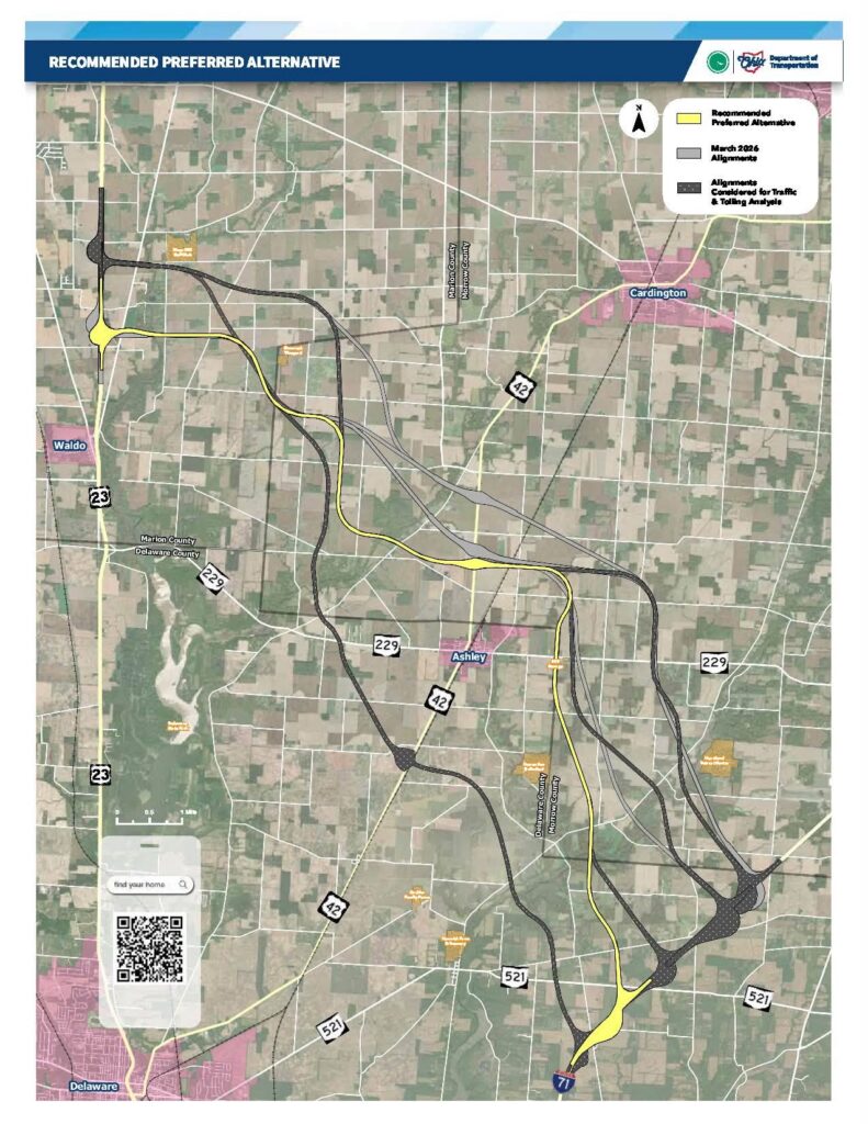
ODOT’s latest update makes its case why balance, not the fastest route, is driving the U.S. 23/I-71 study. A possible new freeway connection between U.S. 23 and I-71 has moved another step forward, with state transportation officials now pointing to a recommended preferred alternative after months of study, public input, and technical review.
The Ohio Department of Transportation released an updated findings video on Thursday, July 30, outlining the latest work on the U.S. 23/I-71 Connector Feasibility Study. The presentation reviews what has changed since public meetings were held in March, including engineering refinements, traffic modeling, cost estimates, toll-revenue analysis, and the reasoning behind the preferred alignment now being recommended for further consideration.
The video can be seen here:
The study stems from language in Ohio’s fiscal year 2026-2027 transportation budget, which directed ODOT to evaluate the feasibility of creating a connection between U.S. 23 and I-71. The idea has drawn attention across Delaware, Marion, and Morrow counties because of its potential to reshape regional traffic patterns, affect farmland and local roads, and alter how traffic moves between the Toledo and Columbus areas.
Delaware County would be profoundly impacted in multiple ways, particularly in the Ashley area.
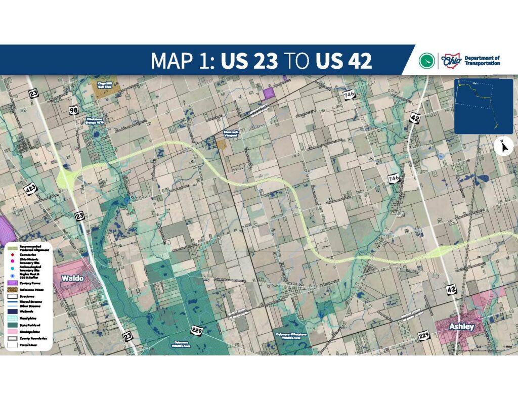
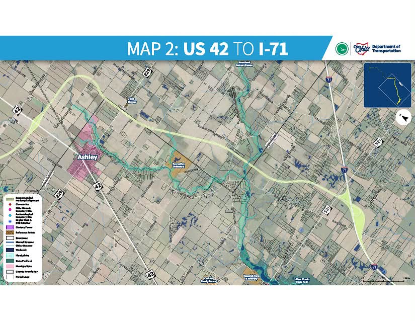
Since the March public meetings, ODOT said the alignments have been refined using both community feedback and engineering analysis. Those refinements focused on preserving farmland by reducing the division of agricultural fields, avoiding the creation of landlocked parcels, minimizing impacts to streams and other environmental resources, and providing grade-separated crossings for local roads. The latter issue is particularly important for emergency response times, school bus routes, and daily travel patterns in rural areas.
The technical analysis also looked at how much the connector would be used and how much time it could save, ODOT said. According to ODOT, traffic modeling found that the length of the connector and the location of its tie-in with I-71 make a significant difference. The study identified a gap of about 7,500 vehicles per day between the southernmost and northernmost alignments.
The projected travel-time savings are more modest during normal traffic conditions, but more substantial during peak commuting periods. ODOT estimates that a connector could reduce travel times between Toledo and Columbus by about 5 to 8 minutes during non-peak periods and by 20 to 23 minutes during the morning peak hour.
Cost remains a major factor. The alternatives evaluated by ODOT carry estimated project costs ranging from $650 million to $740 million in present-day dollars. Tolling was also reviewed, but the study found that toll revenue would cover only a limited share of construction costs. Depending on the alignment, toll revenue was projected to contribute anywhere from 0% to 13% of total construction costs.
That analysis shaped its reasoning, ODOT claimed. The southernmost alignment generated the strongest projected traffic volumes and the highest toll-revenue potential, but it also presented the greatest environmental and historic-resource risks. Those included possible impacts to historic properties, archaeological resources, parklands, and wildlife areas. For that reason, ODOT said it was not recommended for further consideration.
The northernmost alignment presented the opposite trade-off. It had fewer environmental impacts and lower risk, but also generated weaker traffic projections and limited toll-revenue potential. It, too, was not recommended for further consideration.
ODOT framed the recommended preferred alternative as a middle-ground choice, not the option that ranked highest in any single category. The agency said the goal was to identify the alternative that offered the best overall balance among environmental impacts, community effects, projected traffic use, travel-time savings, project cost, and toll feasibility.
The public comment period remains open through September 1. ODOT said comments will be reviewed and documented as part of the final feasibility study, which is scheduled to be submitted to the Ohio General Assembly by October 1. Substantial public review and opposition has already surfaced, with some suggesting alternate routing in the same general area of southern Morrow County.
Even then, the connector would not be a done deal. ODOT emphasized that additional environmental studies, engineering work, and public involvement would be required if the project moves forward. Decisions about whether, how, and when to build a connector would still depend on future policy decisions, legislative action, funding, and implementation planning.
Three maps shared by ODOT are below.